


My wife asked me one question the other day.
“What is El Niño?”
I work with oceans every day, so I knew what it was. Explaining it simply was harder.
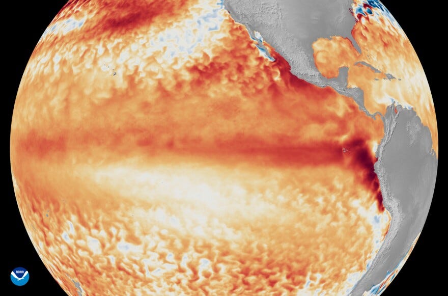
My first answer was that El Niño is where surface waters in the tropical Pacific get much warmer than normal… which is basically right, but the interesting part starts when you ask what “warmer than normal” actually means.
NOAA identifies El Niño when the Niño 3.4 region of the tropical Pacific is at least 0.5°C warmer than average, the temperature anomaly persists or is expected to persist across five overlapping three-month periods, and the atmosphere above it shows changes associated with El Niño.
Half a degree.
Then I looked at what is being forecast right now, and the Met Office model is showing temperatures in that same region rising to more than 3°C above average in the coming months. Professor Adam Scaife, its Head of Long Range Forecasting, said he had never seen an El Niño signal this intense in its forecasts, describing 1°C to 2°C of warming in the equatorial Pacific as typical, with 2°C already a really big event.
NOAA is also forecasting an exceptional event. On 13 August it put the chance of a very strong El Niño through autumn and winter at more than 90%. For October to December, NOAA also gave a 69% chance of a historic event on its Relative Oceanic Niño Index, or RONI, reaching +2.5°C or more, which would exceed previous El Niño events in its record going back to 1950.
So, if roughly half a degree is enough to mark El Niño conditions, what does more than three degrees mean? I can’t be the only one who thinks that this sounds completely terrifying.
The 3°C forecast does not mean the whole Pacific suddenly becomes 3°C hotter, and it certainly does not mean global temperature rises by 3°C. It is a forecast anomaly in a defined part of the tropical Pacific. Even with that caveat, it is an extraordinary number.
Warm water is only part of what changes during El Niño. Normally, trade winds blow across the tropical Pacific from east to west. They help push warm surface water towards Asia. Around South America, colder water rises from deeper in the ocean to replace it, bringing nutrients towards the surface.
During El Niño, those winds weaken. More warm water spreads east; the warm upper layer becomes deeper in the eastern Pacific, and some of that colder, nutrient-rich water has a harder time reaching the surface. Rainfall shifts with the warm water, and the atmosphere responds too.
That is how something happening in the Pacific can affect weather thousands of miles away. Warm water off South America does not directly create a storm over Britain. El Niño changes large-scale circulation in the ocean and atmosphere, and that changes the odds of different kinds of weather occurring in different places.
That changes the odds, not the forecast outside my house in November.
For the UK, the Met Office says the developing El Niño increases the chance of wetter and stormier conditions across north-west Europe during autumn and early winter.
Have you seen the colour of the UK? I appreciate that “look at the lawn” isn’t normally the opening line of a rigorous climate analysis, so I checked the numbers.
As of 18 August, 71% of England by land area was in drought. Reservoir storage was 62.6%, 16.3 percentage points below average for the time of year. Around 29 million people were living with restrictions on their water use. The Environment Agency was reporting poor grass growth, reduced crop yields and exceptionally hard ground.
So we need rain, pretty damn badly. The question I kept coming back to was what happens if a lot of it arrives at once.
Drought and flooding sound like opposites, but they can happen surprisingly close together. When soil becomes extremely dry and compacted, intense rain can struggle to soak into it quickly enough. More water runs across the surface instead. A place can badly need rain and still flood locally when too much arrives too quickly.
That does not mean El Niño is going to flood Britain. The Met Office is saying the chance of wetter and stormier conditions increases. That is a different claim, and an important one given the country’s condition going into autumn.
For me, the more interesting part is still what happens beneath the surface of the Pacific.
If less cold, nutrient-rich water reaches the surface, you can change the food web. Fish move as temperature and food change. Other animals may have to follow them.
My mind obviously goes to whales. For some whale populations, the effect can become very practical. In the northeast Pacific, research has found that El Niño conditions can disrupt krill distribution and alter blue whale presence in primary feeding areas. A whale can arrive on a familiar feeding ground and find less food there than usual. There is no universal rule saying El Niño does one particular thing to whales, but changing productivity can move the food and the animals following it.
Corals give a much more brutal example. At Jarvis Island in the central Pacific, NOAA researchers recorded hard coral cover falling from 18.7% in April 2015 to 0.4% by May 2016 during the 2015 to 2016 El Niño and prolonged marine heat stress. The corals experienced maximum heat stress for 66 consecutive weeks, and NOAA recorded mass mortality across coral groups, depths, and parts of the island.
That is the sort of consequence I mean when I say species and habitats can get absolutely hammered.
The bit I got wrong was what climate change has done to El Niño. My assumption was that El Niño was happening more regularly and that we were seeing stronger El Niños year after year.
I checked that assumption against the IPCC, and it does not hold.
The IPCC says El Niño and La Niña naturally vary a lot from one decade to the next. There is no clear evidence that they are happening more often over the long term, and scientists do not yet agree that the Pacific temperature swings linked to them will consistently become stronger this century. Those swings have been larger since 1950 than they were between 1910 and 1950, but the older records are less certain, so scientists cannot yet say this is part of a lasting trend.
The clearest projection is rainfall. The IPCC says it is very likely that the changes in rainfall linked to El Niño and La Niña will become stronger later this century as the climate warms. That doesn’t mean this particular El Niño will automatically bring extreme rain everywhere. It means that, in a warmer world, El Niño and La Niña are expected to have more influence over rainfall patterns.
So I had one part of it wrong. El Niño is natural. It has happened before, and it will keep happening. What’s changed is the climate in which these events are now taking place.
Dr Nick Dunstone, a Met Office climate scientist, says a large El Niño releases significantly more heat from the ocean into the atmosphere, with the biggest effect on global temperature often appearing in the calendar year after its winter peak. On the strength of the event now developing, he says 2027 is very likely to replace 2024 as the warmest year on record and temporarily exceed 1.5°C above the preindustrial level.
That does not mean a single year above 1.5°C is the same thing as permanently breaching the Paris Agreement’s long-term temperature goal. It does show how much heat a large El Niño can release from the ocean into the atmosphere.
Then I started worrying about preparation. My first reaction was that we are sleepwalking into a disaster where people, species and habitats could be absolutely hammered by adverse weather while we are still enjoying barbecues because the weather is nice.
I found myself wondering where the practical advice was. If you live by a river, should you be buying sandbags? Should people be preparing their homes for bad weather? Are ordinary people actually being told what any of this means?
I was wrong about that too. The government is assessing the developing El Niño as forecasts evolve. Its 2026 resilience reporting notes that previous El Niños have increased the likelihood of mild, wet and windy conditions in early winter and drier, colder conditions later, while stressing that El Niño is only one of several climate drivers. The Environment Agency is already responding to drought, and practical flood advice tells people in at-risk areas to check their risk, sign up for warnings and make a flood plan.
So my first claim, that there was no preparation or advice, was wrong.
I still think there is a communication problem. We have El Niño headlines, drought reports, flood warnings, weather forecasts and government resilience documents.
She’d only asked me what El Niño was, and here we are!
If this helped make El Niño a little easier to understand, and you value journalism that takes the time to go back to the science rather than just repeat the headline, please do consider becoming a paid subscriber.
Paid subscriptions help fund the reporting, research, and time behind Ocean Rising, and let me keep chasing the ocean stories that deserve more than a quick take.
If you’re already a paid subscriber, thank you. You’re quite literally helping make this work possible.
Like thanks as always for your articles. That the AMOC is slowing down due to the warming oceans plus extreme weather is on the rise. It looks like earthquakes are on the rise as well. So definite cause for serious concern. Bob